Datameteo Agro : Accurate weather forecast for agrometeorology
In agriculture and the environment is very important knowing in advance with some reliability whether it will rain or not, if there are late frosts, hail damaging, flash floods or drought with high temperatures. This allows to program any irrigation operation, crop spraying and phyto-sanitary treatments or activate a protection from hail or fire.
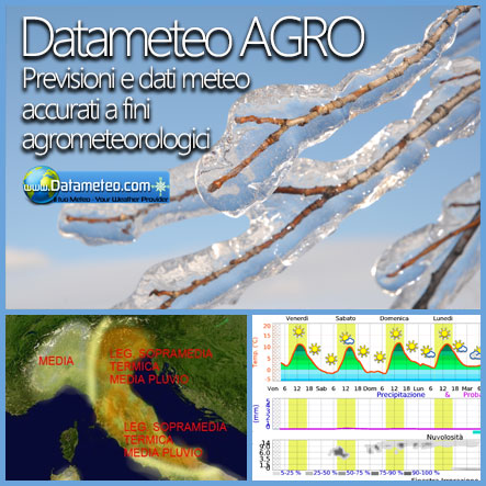
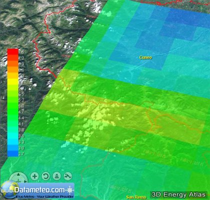
High Resolution Weather Agro Forecast Data and Spray window
To schedule sowing, haymaking, spraying, irrigation, pest control task, a useful instrument can be the "spraying window". The Spray window shows conditions for crop protection measures based on weather forecast at the chosen location. Combining various high resolution forecast outputs like air and skin temperature, humidity, wind, precipitation, evapotranspiration, soil moisture you can know in advance if the treatment can be done. An intuitive color scale bar indicates the spraying window suitable (green), less suitable (yellow) and unsuitable (red) periods for application.
The advice should be controlled before making the application. These data can be used in agriculture, silviculture and gardening, for planning measures which are affected by the conditions of atmosphere. It shows a forecast for the area, which can be adapted to local conditions and land management through experience. For important decisions, frequent comparisons with local observations should be carried out.
Seasonal long term forecast
In the latest years climate change has created serious difficulties who must make choices in the medium long term. A service at affordable rates that offers climate trends over the coming months is a good investment to support decision making processes, or to establish an action plan for the implementation of a long term company strategic activity plan.
Our Mission is to provide a simple and a clear information on future weather scenariosin order to plan activities and medium-and long-term as: monitoring potential risk, investment sourcing, advertising campaigns, choice of colture, ecc.
High resolution weather forecast data can be used to prevent
Viticulture: Downy Mildew, Powdery Mildew, Moth of the Bunch
Arboriculture: scab, bacterial infestations
Other crops: fungal diseases, development of other pests
This is an intuitive index based on a color bar scale to plan crop protection measures Color green: suitable period
yellow: less suitable period
red: unsuitable period
The report is an intuitive instrumemt to have a brief overview on a ipotetical mid-long term seasonal trend. In this way you can have an idea about the future probabilistic scenario in terms of climate parameters deviation from the average of the season
Outputs
-Temperature 2m °C, Skin Temperature °C, Dew Point °C
-Relative Humidity %
-Precipitations (mm)
-Snow (cm) / Melted Snow (cm)
-Run off (mm)
-Wind Direction in (°) , Speed (m/s)
-Cloudiness %
-ETP Evapotranspiration (mm)
-Leaf Wetness
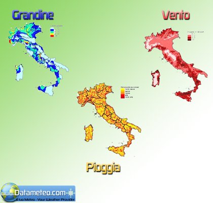
Index composed by:
-Precipitation (mm), Wind Direction (°) , Speed (m/s)
-ETP Evapotraspiration (mm) , Leaf Wetness,
-Temperature 2m °C, Skin Temperatura °C,
-Relative Humidity (%)
Climate trends are available in various formats. The most intuitive is the report with some maps update regularly. Raw data , specific anomalies or climate maps can be requested as option
Technologhy used
ENS, MOS with agro meteo weather station data Data validation
ENS, MOS with agro meteo weather station data Data validation
CFS climatological model, Climate Teleconnections Manual report elaboration by our staff of meteorologists
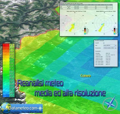
Worldwide Weather Archive and Reanalysis for evaluating extreme meteorological events expertise
Datameteo archives and reanalisys are the new weatther instruments used by our skilled meteorologist to provide a clear and detailed graphical dna textual report on every extreme weather events occured worldwide that needs to be investigated.
Nowadays weather is one of the most important word in our daily life. Internet is full of weather sources and for many people the search of the most reliable forecast this is becoming a true obsession. Professional services try to keep account of the caotic state of the atmosphere and knowing the past, present weather data is the first foundamental step to build an accurate forecast.
Yesterday and actual weather can be known not only in places where a meteorological station is installated.
Satellite feeds and the new weather tecnologies fronties (reanalysis) can help us to have data in places with poor density o total absence of weather stations.
Datameteo manages WRF-NMM and WRF-EMM weather models with high horizontal resolutions for creating archives of quality reanalisys weather logged timeseries available in one click. This approach can easly integrate the worldwide validate past weather data coming form thounsands of weather stations.
In this way you can have a global past and actual validate data weather coverage in the format of your choice at affordable rates
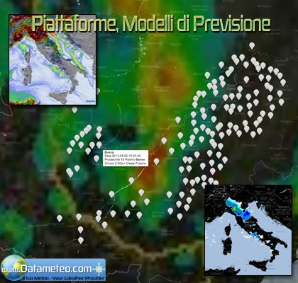
In the latest years climate change has created serious difficulties who must make choices in the medium to long term. A service at affordable rates that offers climate trends over the coming months is a good investment to support decision making processes, or to establish an action plan for the implementationfor a long term company strategic activity plan. This warning service uses the potential of a specif ensemble hail index (Hail, composite index + Significant hail parameter) in house developed with the integration of various multiphysical high resolutions weather WRF models scheme.
The service gives a weather forecast focus on the next 84 hours updated 2 times a day with manual tuned hail index, hail size, grain size output. The unique combination of the various forecasted outputs allow us to build a service specifically tailored on the customer needs. The horizons can be very different from one business branch to another.
Our Mission is to provide a simple and a clear information on future weather scenarios in order to plan activities and medium and long-term as: monitoring potential risk, investment sourcing, advertising campaigns, choice of colture.ecc.
Energy, agriculture, transportation, construction, municipalities, school districts, travel, food processors, retail sales and real estate are all examples of industries whose operations and profits can be significantly affected by the weather.
For example, unusually mild winters diminish consumer demand for heating and erode the profit margins for utility companies. Unexpected weather events can cause significant financial losses. We give you the right instruments such weather information and accurate forecasts to be utilized in risk management and decision making.
� Datameteo tutti i diritti riservati - Modellistica ed Elaborazione Dati di LRC Servizi Srl P.I 03358090045. Base inizializzazione dati NOAA .
Ottimizzato per Firefox-Safari-Chrome-IE8 LRC Servizi Srl - C.C.I.A.A. Cuneo R.E.A. n. 284623 - Reg. Imprese C.F. Partita IVA: 03358090045


